Let’s start a long way away and move closer.

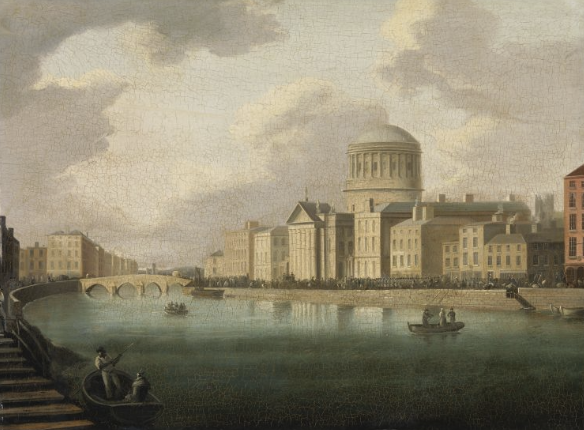
You can just see the dome in the distance in this painting by William Sadler from c.1800. Zoom in here.

Getting a little closer. The bridge in this zoomable painting is Barrack Bridge at Watling Street and the bridge behind it is Queen Street bridge.

The next bridge, right before the Four Courts, is still there but now leads on to Church Street. In the summer evening light the view looks almost Italianate. Zoom in here.

A very early view of the Four Courts, 1805. You can see the old Ormond Bridge (destroyed by flood around this time) well downriver from where its replacement now is. The line of the river is slightly different and there is no barrier between the quay and the river outside the Four Courts. The zoom facility here shows that one of the ladies on the cart is carrying a parasol.

The Ormond Bridge has now been replaced by the Richmond (now O’Donovan Rossa) Bridge, erected 1812. This is a very early image of this bridge. So early, in fact, that a zoom shows that the wall between the quay and the river outside the Four Courts put up in conjunction with the new bridge is not yet in place.

The same view by Brocas and Le Petite, 1818. The wall is now up. Morgan Place as we know it does not yet exist. Zoom for an impressive array of local detail.

The same view by Lavelle and Roberts, c. 1830. Again, a zoom shows lots of interesting day-to-day goings on. Very little change in general layout, other than the quay seems to have slightly widened at the Richmond Bridge point.

A few more of the same view from the mid-19th century. This one shows an impressive amount of river traffic, including one vessel with glamorously dressed male and female passengers on a day out. The hat on one of the ladies is to die for. Zoom here.

An equally impressive amount of quay traffic here. Zoom here to view it (and the fisherman right outside the western wing!) in close-up.

Smoke coming out of a chimney on the western wing above. The boats and quay traffic can be viewed in more detail here.

The soldiers on the quays above can be zoomed in on here. The strong military presence in Dublin is very obvious in a number of these images.

No military here! A photograph of crowds on Arran Quay for Parnell’s funeral in 1891.

A turn of the century 1900 photograph of the eastern side of the Four Courts. The large building on Inns Quay next to Morgan Place is the Four Courts Hotel. Zoom here.

British soldiers in front of the Four Courts Hotel during the 1916 Rising.

After the Battle of the Four Courts, 1922. This zoomable photograph shows the still burning eastern side of the Four Courts.

Some more cheerful views! This mid-20th century Churchman’s Cigarette card shows the reconstructed Four Courts.

A sylvan late 20th century Four Courts, with a Guinness barge passing. Spot the Bovril sign!

Late 1960s. The Four Courts Hotel buildings were demolished and replaced by the large red-brick Aras Ui Dhalaigh in the 1980s. Morgan Place was also considerably widened.

Aras Ui Dhalaigh. It’s quite difficult to find a photo of the Four Courts including it. Photographers now tend to cut their shots off at the end of the western wing.

An alternative solution sometimes employed is to shoot in summer when Aras Ui Dhalaigh is concealed by trees. A very nice shot from wikimedia commons! We need lots more trees along the quays!
To view more historical images of the Four Courts and its environs, click on the following links:
Dublin City Council Digital Archive
South Dublin County Council Digital Archive
University College Dublin Digital Library
National Museum (recommended search word: courts)


